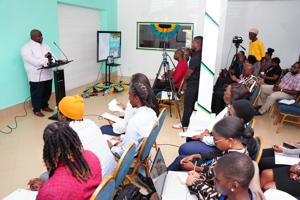
A Cabinet minister said yesterday that the government is building capacity to monitor the country’s land and marine resources through the launch of the Drone Mapping Data Unit (DMDU). Leon Lundy, minister of state in the Office of the Prime Minister, and acting minister of agriculture and marine resources (MAMR), said at yesterday’s launch of the DMDU that it has always been a challenge to monitor the country’s coastal zones and terrestrial landscape, but now with the advancement of drone technology, the government is becoming more equipped to do so. “The MAMR is striving to use innovative technologies and methodologies to improve our services to the Bahamian people,” said Lundy.
The DMDU was created in partnership with the Food and Agriculture Organization (FAO) and Marine Spatial Information Solutions (MARSIS), with the FAO providing the drones along with training, and MARSIS delivering on the training of the drone pilots. “This drone technology was provided to The Bahamas to build capacity in the agricultural, coastal, marine, and disaster risk management applications,” said Lundy. “This comprehensive training supports agriculture, coastal and marine applications, utilizing online learning management systems, training and technical support for flexibility and adaptability to national project agendas.

“This presented the ministry with a unique opportunity to build capacity through the use of drone technology. The drones donated to the country are equipped .