There are seemingly endless ways to appreciate Red Rock Canyon Open Space, one of Colorado Springs' signature, natural beauties. Out-of-towners might take to the often-recommended Contemplative Trail, finding themselves tucked between the slanting, soaring outcrops on the open space's west side. On the other side, locals on foot and bike take to the Hogback Trail, named for the defining formation there.
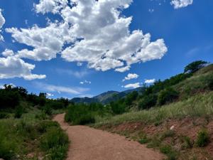
And others ascend trails in the middle of the park, rising to upper reaches that overlook the colorful vicinity. That was the experience of our latest visit to Red Rock Canyon. It's a simple course at a glance at the handy trail map posted on the Friends of Red Rock Canyon's website .

Atop the group's trail descriptions is this loop connecting Mesa Trail with Greenlee Trail — a lovely tour of the open space's north and south limits. Mesa Trail starts from the main parking area, up from the restrooms and signage. The first half of the trip is all uphill, though the vertical isn't nearly harsh enough to distract from the vistas that open up through the greenery, including a stately Pikes Peak.
Continue onward toward the foothills that loom ahead, ignoring splits along the way. Close to 1.5 miles, the wide path winds around and crests at a big-sky, grassy expanse, overlooking the city, plains, Garden of the Gods and slot canyons on either side.
Greenlee Trail is well-marked, the thin path to the left running down. The stretch appeals to mountain bikers, who flow fast through a .